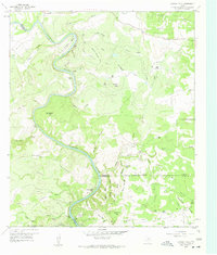
1959 Map of Gorman Falls
USGS Topo · Published 1959About this map
Colorado River meanders sharply through this central Texas landscape, marking the jagged boundaries between San Saba, Lampasas, and Burnet Counties. The terrain is defined by complex canyon systems and named ridges, most notably Lemons Ridge and Post Oak Ridge. This late 1950s survey captures the area's rural character, dominated by family-named holdings such as Jackson Ranch and Smith Ranch. High-relief features like Bull Knob and Sullivan Knob overlook deep draws and hollows, while the river corridor is punctuated by hydrologic landmarks including Gorman Falls and the nearby Gorman Spring. The map documents a sparsely populated region where life followed the breaks of the land, showing isolated outposts like Lemons Springs Camp and the industrial footprint of the Southwest Ledge Quarries in the north. This document provides a record of the specific locations of remote springs, such as Coffin Springs and Burnt Canyon Spring, which were vital for ranching and early settlement in this part of the Edwards Plateau.
Find a feature on this map
69 named features on this map. Tap any name to fly to it.
Don’t see what you’re looking for? This feature index may not catch every label — zoom into the map to look around manually.
Map Details
Editions of this 1959 Gorman Falls Map
Other maps of this area

1885 · San Saba
USGS Topo · 1:125,000

1887 · Llano
USGS Topo · 1:125,000

1887 · Lampasas
USGS Topo · 1:125,000

1887 · Burnet
USGS Topo · 1:125,000

1893 · Burnet
USGS Topo · 1:125,000

1894 · Lampasas
USGS Topo · 1:125,000

1894 · San Saba
USGS Topo · 1:125,000

1894 · Llano
USGS Topo · 1:125,000

1903 · Burnet
USGS Topo · 1:125,000

1904 · Llano
USGS Topo · 1:125,000