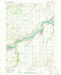
1958 Map of Grand Rapids
USGS Topo · Published 1973About this map
The Maumee River defines this portion of the Ohio landscape, serving as the border between Lucas and Wood Counties and shaping the development of riverbank settlements. Along its northern bank, the path of the Miami and Erie Canal (Abandoned) remains visible, a relic of early nineteenth-century transport that once fueled the local economy. The village of Grand Rapids sits at a prominent bend in the river, connected by a bridge to the northern shore near the Providence Church. The map details a transition from the waterway's complex island system, including Missionary Island and Indian Island, to the organized grid of rural farm roads such as Yawberg Road and Kellogg Road. Genealogists will find numerous family landmarks and burial sites, including Beaver Creek Cemetery and Washington Cemetery, reflecting the area's deep agricultural roots.
Find a feature on this map
63 named features on this map. Tap any name to fly to it.
Don’t see what you’re looking for? This feature index may not catch every label — zoom into the map to look around manually.
Map Details
Editions of this 1958 Grand Rapids Map
3 editions found
Other maps of this area

1900 · Toledo
USGS Topo · 1:62,500

1901 · Bowling Green
USGS Topo · 1:62,500

1903 · Bowling Green
USGS Topo · 1:62,500

1909 · Mc Clure
USGS Topo · 1:62,500

1911 · Swanton
USGS Topo · 1:62,500

1914 · Swanton
USGS Topo · 1:62,500

1935 · Grand Rapids
USGS Topo · 1:24,000

1935 · Whitehouse
USGS Topo · 1:24,000

1935 · Maumee
USGS Topo · 1:24,000
1938 · Maumee
USGS Topo · 1:31,680