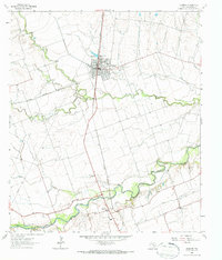
1964 Map of Granger
USGS Topo · Published 1987About this map
Granger serves as the primary hub of this Williamson County landscape, centered on the intersection of the Missouri Kansas Texas railroad and the Railroad Reservoir. The 1960s-era settlement pattern reveals a town shaped by transit and agriculture, featuring the Crispus Attucks Sch and several religious landmarks such as Holy Cross Cem and Calvary Cem. To the south, the San Gabriel River meanders toward the southeast, defining the southern border near the small communities of Circleville and Waterloo. The topography is marked by several watercourses including Willis Creek, Yankee Branch, and Pecan Creek, which cut through the terrain. Numerous family and community cemeteries, such as Machu Cem and the Sloan Easley Cem, provide vital touchpoints for genealogists researching the rural history of central Texas during this mid-century period.
Find a feature on this map
24 named features on this map. Tap any name to fly to it.
Don’t see what you’re looking for? This feature index may not catch every label — zoom into the map to look around manually.
Map Details
Editions of this 1964 Granger Map
3 editions found
Other maps of this area

1885 · Taylor
USGS Topo · 1:125,000

1887 · Taylor
USGS Topo · 1:125,000

1893 · Georgetown
USGS Topo · 1:125,000

1894 · Taylor
USGS Topo · 1:125,000

1925 · Georgetown 4-d
USGS Topo · 1:48,000

1928 · Round Rock
USGS Topo · 1:62,500

1949 · Round Rock
USGS Topo · 1:62,500

1951 · Round Rock
USGS Topo · 1:62,500

1954 · Austin
USGS Topo · 1:250,000

1963 · Friendship
USGS Topo · 1:24,000