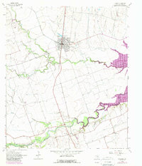
1964 Map of Granger
USGS Topo · Published 1989About this map
Granger serves as the focal point of this Central Texas landscape, situated at the confluence of agricultural prairie and the winding river bottom. The map captures a significant period of transformation as the San Gabriel River corridor is reshaped by the rising waters of Granger Lake. This transition is most evident in the southeast, where the river valley begins to broaden into the lake's basin near Waterloo. Local history is deeply embedded in the rural infrastructure, particularly through the numerous family and community burial grounds such as Sloan-Easley Cem, Gardner Cem, and Macedonia Cem. The presence of the Crispus Attucks Sch in Granger highlights the educational history of the town. Multiple watercourses, including Willis Creek, Yankee Branch, and Pecan Creek, define the drainage patterns that once supported the area's farming economy before the mid-century hydrological changes.
Find a feature on this map
24 named features on this map. Tap any name to fly to it.
Don’t see what you’re looking for? This feature index may not catch every label — zoom into the map to look around manually.
Map Details
Editions of this 1964 Granger Map
3 editions found
Other maps of this area

1885 · Taylor
USGS Topo · 1:125,000

1887 · Taylor
USGS Topo · 1:125,000

1893 · Georgetown
USGS Topo · 1:125,000

1894 · Taylor
USGS Topo · 1:125,000

1925 · Georgetown 4-d
USGS Topo · 1:48,000

1928 · Round Rock
USGS Topo · 1:62,500

1949 · Round Rock
USGS Topo · 1:62,500

1951 · Round Rock
USGS Topo · 1:62,500

1954 · Austin
USGS Topo · 1:250,000

1963 · Friendship
USGS Topo · 1:24,000