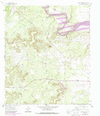
1962 Map of Green Mountain
USGS Topo · Published 1988About this map
The Colorado River corridor in Coke County underwent a significant transformation as documented in this 1980s revision, showing the anticipated boundaries of Lake E V Spence. Purple hatching marks the extensive areas slated for submergence under the reservoir, which would eventually alter the landscape around the Millican Field and numerous local waterways. Before the rising waters, the area supported a rural network of ranching and energy extraction, evidenced by the South Lygay Oil Field and various Oil Wells scattered across the limestone breaks.
Find a feature on this map
21 named features on this map. Tap any name to fly to it.
Don’t see what you’re looking for? This feature index may not catch every label — zoom into the map to look around manually.
Map Details
Editions of this 1962 Green Mountain Map
3 editions found
Other maps of this area

1954 · Big Spring
USGS Topo · 1:250,000

1954 · San Angelo
USGS Topo · 1:250,000

1958 · San Angelo
USGS Topo · 1:250,000

1958 · Big Spring
USGS Topo · 1:250,000

1959 · Silver
USGS Topo · 1:24,000

1959 · Dead Indian Mountain
USGS Topo · 1:24,000

1962 · Edith
USGS Topo · 1:24,000

1962 · Sanco
USGS Topo · 1:24,000
1962 · Millican Mountains
USGS Topo · 1:24,000

1962 · Green Mountain
USGS Topo · 1:24,000