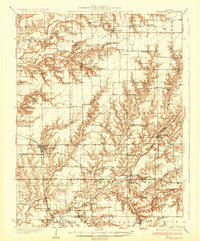
1932 Map of Greenfield
USGS Topo · Published 1932About this map
Greenfield serves as a central hub for the Illinois prairie in the early 1930s, situated at the junction of the Chicago Burlington and Quincy and the Chicago and Alton railroads. The landscape is defined by the winding drainages of Apple Creek and Macoupin Creek, which create deep-cut valleys that contrast with the organized grid of upland farmsteads. This survey captures a dense network of rural infrastructure, from the Woodbine Country Club to more than twenty-five neighborhood schoolhouses such as Sunny Point Sch and Oak Hill Sch. The mapping of small settlements like Athensville and Scottville alongside family cemeteries like Rhodes Cem and Stultz Cem reflects a highly localized community structure. Transportation is transitioning as State Highway No 108 appears alongside the older rail corridors, while the presence of a Landing Field near the Macoupin indicates the burgeoning era of aviation in rural Greene County.
Find a feature on this map
83 named features on this map. Tap any name to fly to it.
Don’t see what you’re looking for? This feature index may not catch every label — zoom into the map to look around manually.
Map Details
Editions of this 1932 Greenfield Map
3 editions found

Other maps of this area

1912 · Gillespie
USGS Topo · 1:62,500

1915 · Gillespie
USGS Topo · 1:62,500

1923 · Carlinville
USGS Topo · 1:48,000

1924 · Winchester
USGS Topo · 1:48,000

1924 · Waverly
USGS Topo · 1:62,500

1924 · Roodhouse
USGS Topo · 1:62,500

1925 · Carlinville
USGS Topo · 1:62,500

1925 · Brighton
USGS Topo · 1:62,500

1926 · Winchester
USGS Topo · 1:62,500

1926 · Waverly
USGS Topo · 1:62,500