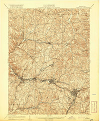
1906 Map of Greensburg
USGS Topo · Published 1920About this map
Greensburg and Jeannette anchor this early 20th-century landscape, appearing as dense nodes of development amidst a complex network of Westmoreland County townships. The industrial and transportation identity of the region is defined by the Pennsylvania RR, which follows the contours of Brush Creek and Turtle Creek, branching off into numerous spurs like the Manor Branch and Lyons Run Branch. These rail lines connect coal-patch towns and boroughs such as Export, Manordale, and Harrison City. Outside the primary urban corridors, the map reveals a rural fabric of crossroads and family-named landmarks. Features like the Bulltown Schoolhouse and Plum Creek Church serve as vital markers for genealogists tracing local community centers. The winding course of Loyalhanna Creek in the northeast and the prominent County Home near the county seat reflect the diverse social and topographic character of the era.
Find a feature on this map
91 named features on this map. Tap any name to fly to it.
Don’t see what you’re looking for? This feature index may not catch every label — zoom into the map to look around manually.
Map Details
Editions of this 1906 Greensburg Map
6 editions found


Other maps of this area

1900 · Latrobe
USGS Topo · 1:62,500

1902 · Latrobe
USGS Topo · 1:62,500

1902 · Brownsville
USGS Topo · 1:62,500

1902 · Connellsville
USGS Topo · 1:62,500

1902 · Elders Ridge
USGS Topo · 1:62,500

1903 · Latrobe
USGS Topo · 1:62,500

1904 · Elders Ridge
USGS Topo · 1:62,500

1904 · Mc Keesport
USGS Topo · 1:62,500

1904 · Greensburg
USGS Topo · 1:62,500

1906 · Brownsville
USGS Topo · 1:62,500