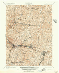
1906 Map of Greensburg
USGS Topo · Published 1951About this map
The Pennsylvania RR and its numerous spurs, such as the Turtle Creek Branch and Hempfield Branch, anchor the industrial landscape of Westmoreland County at the turn of the century. The map illustrates a region transitioning into a coal and rail hub, where established stage routes like the Philadelphia Pike meet the growing electric infrastructure of the West Penn Electric line. Small crossroads settlements like Newlonsburg, Claridge, and Harrison City dot the hills between deep-cut waterways such as Turtle Creek and Brush Creek. Genealogy researchers will find valuable landmarks of early community life, including the Bulltown Schoolhouse, Plum Creek Church, and the Penn Sta (P O) mail hub. The dense contouring reveals the steep ravines of the Allegheny Plateau that dictated the winding paths of the Youghiogheny Branch and influenced the growth of centers like Westmoreland City and Irwin.
Find a feature on this map
90 named features on this map. Tap any name to fly to it.
Don’t see what you’re looking for? This feature index may not catch every label — zoom into the map to look around manually.
Map Details
Editions of this 1906 Greensburg Map
6 editions found


Other maps of this area

1900 · Latrobe
USGS Topo · 1:62,500

1902 · Latrobe
USGS Topo · 1:62,500

1902 · Brownsville
USGS Topo · 1:62,500

1902 · Connellsville
USGS Topo · 1:62,500

1902 · Elders Ridge
USGS Topo · 1:62,500

1903 · Latrobe
USGS Topo · 1:62,500

1904 · Elders Ridge
USGS Topo · 1:62,500

1904 · Mc Keesport
USGS Topo · 1:62,500

1904 · Greensburg
USGS Topo · 1:62,500

1906 · Brownsville
USGS Topo · 1:62,500