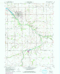
1960 Map of Greentown
USGS Topo · Published 1982About this map
Wildcat Creek meanders through the heart of this Indiana agricultural landscape, defining the character of eastern Howard County and northern Tipton County. The hub of activity centers on Greentown, where the Eastern Sch and a network of local roads like Pickering Road anchor the community. To the west, the Kokomo Waterworks Res No 2 and the Howard County Airport reflect mid-century infrastructure developments. Small rural settlements and crossroads such as Jerome, West Liberty, and Phlox are connected by an extensive system of drainage canals, including Roberts Ditch and Legg Ditch, which were essential for managing the fertile plains. The map also captures several points of genealogical interest, from the Union Civil Cem near the creek to the Howard Chapel and Salem Cem in the southern reaches.
Find a feature on this map
54 named features on this map. Tap any name to fly to it.
Don’t see what you’re looking for? This feature index may not catch every label — zoom into the map to look around manually.
Map Details
Editions of this 1960 Greentown Map
4 editions found

Other maps of this area

1953 · Danville
USGS Topo · 1:250,000

1953 · Muncie
USGS Topo · 1:250,000

1955 · Danville
USGS Topo · 1:250,000

1956 · Muncie
USGS Topo · 1:250,000

1956 · Danville
USGS Topo · 1:250,000

1959 · Miami
USGS Topo · 1:24,000

1960 · Elwood
USGS Topo · 1:24,000

1960 · Point Isabel
USGS Topo · 1:24,000

1960 · Kokomo East
USGS Topo · 1:24,000

1960 · Tipton
USGS Topo · 1:24,000