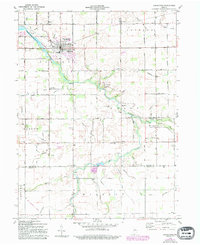
1960 Map of Greentown
USGS Topo · Published 1994About this map
Wildcat Creek meanders through this portion of eastern Howard County, serving as the primary drainage for a landscape defined by agriculture and small crossroads settlements. This 1960 edition, with revisions through 1994, shows the growth of Greentown near the Kokomo Waterworks Res No 2 and the Eastern Sch. Small communities like Jerome, Sycamore, and West Liberty are well-defined, providing critical landmarks for genealogists and local historians. The map documents an era of infrastructure shifts, including the Howard County Airport and an Old Railroad Grade in the southwest. A high density of rural cemeteries, such as Center Grove Cem and Wheeler Cem, alongside several country churches like New Salem Ch and Howard Chapel, offers a detailed look at the social and religious fabric of the township divisions before late-20th-century consolidation.
Find a feature on this map
51 named features on this map. Tap any name to fly to it.
Don’t see what you’re looking for? This feature index may not catch every label — zoom into the map to look around manually.
Map Details
Editions of this 1960 Greentown Map
4 editions found

Other maps of this area

1953 · Danville
USGS Topo · 1:250,000

1953 · Muncie
USGS Topo · 1:250,000

1955 · Danville
USGS Topo · 1:250,000

1956 · Muncie
USGS Topo · 1:250,000

1956 · Danville
USGS Topo · 1:250,000

1959 · Miami
USGS Topo · 1:24,000

1960 · Elwood
USGS Topo · 1:24,000

1960 · Point Isabel
USGS Topo · 1:24,000

1960 · Kokomo East
USGS Topo · 1:24,000

1960 · Tipton
USGS Topo · 1:24,000