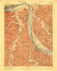
1930 Map of Greenup
USGS Topo · Published 1930About this map
The Ohio River carves a sharp path between Kentucky and Ohio here, anchoring a landscape where river navigation and rail transport defined early 20th-century life. Along the Kentucky bank, the Chesapeake and Ohio railroad connects riverfront communities like Limeville (Tongs PO), Riverton, and Wurtland. The interior is marked by a dense network of hollows and ridges, such as Dogwood Ridge and Nippert Hollow, which historically isolated small settlements. This isolation necessitated a high density of rural institutions, evidenced by the numerous country schools including Forest Academy School, Old Steam Furnace School, and the Plum Grove School. Industrial vestiges are scattered throughout the hills, from Franklin Furnace to the Twin Oaks Mill near Wheelersburg. Transportation across the rugged terrain relied on specific crossings like the Wizard Oil Bridge and Raccoon Bridge, while river traffic was managed at Dam No 30.
Find a feature on this map
157 named features on this map. Tap any name to fly to it.
Don’t see what you’re looking for? This feature index may not catch every label — zoom into the map to look around manually.
Map Details
Editions of this 1930 Greenup Map
3 editions found

Other maps of this area

1898 · Ironton
USGS Topo · 1:62,500

1900 · Ironton
USGS Topo · 1:62,500

1901 · Ceredo
USGS Topo · 1:62,500

1903 · Kenova
USGS Topo · 1:125,000

1904 · Kenova
USGS Topo · 1:125,000

1911 · Sciotoville
USGS Topo · 1:62,500

1912 · Oak Hill
USGS Topo · 1:62,500

1913 · Ceredo
USGS Topo · 1:62,500

1913 · Sciotoville
USGS Topo · 1:62,500

1915 · Garrison
USGS Topo · 1:62,500