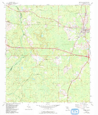
1954 Map of Greenville
USGS Topo · Published 1993About this map
The Greenville community serves as the primary hub of this North Florida landscape, where the flatlands of eastern Jefferson and Madison Counties meet. This survey captures a rural network of churches and family cemeteries that defined the social geography of the era, including New Zion Ch, St Mathews Ch, and St Paul Ch. Waterways dictate the terrain's layout, with the Aucilla River and Little River winding through the northern reaches, while the southern section is drained by Rocky Creek and Alligator Creek. A notable landmark of forest management and surveillance, the Aucilla Lookout Tower, stands prominently above the low-lying basin. The map also reveals the importance of local groundwater and infrastructure through features like the Flowing Well and several distinct burial grounds, such as New Hopewell Cem and Andrews Cem, which offer significant value for genealogical research into the region's long-established families.
Find a feature on this map
22 named features on this map. Tap any name to fly to it.
Don’t see what you’re looking for? This feature index may not catch every label — zoom into the map to look around manually.
Map Details
Editions of this 1954 Greenville Map
Other maps of this area

1954 · Greenville
USGS Topo · 1:24,000

1954 · Greenville NE
USGS Topo · 1:24,000

1954 · Valdosta
USGS Topo · 1:250,000

1955 · Lamont
USGS Topo · 1:24,000

1955 · Shady Grove
USGS Topo · 1:24,000

1955 · Lamont SE
USGS Topo · 1:24,000

1955 · Greenville SE
USGS Topo · 1:24,000

1958 · Valdosta
USGS Topo · 1:250,000

1959 · Valdosta
USGS Topo · 1:250,000

1962 · Ashville
USGS Topo · 1:24,000