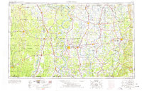
1953 Map of Greenwood
USGS Topo · Published 1978About this map
The Mississippi River and its labyrinthine drainage system define this mid-century portrait of the Delta, where the Arkansas River and White River converge in a landscape of massive islands and cutoffs like Island No 82 and Lake Chicot. This era shows the region's agricultural and industrial infrastructure in full force, anchored by major hubs at Greenville and Greenwood. The dominance of the plantation economy and river trade is evident in the dense network of the Illinois Central Railroad and the Columbus & Greenville Railway, which connect smaller settlements such as Mound Bayou and Indianola. Local civic life is centered on landmarks like the Leflore County Courthouse, while the presence of Greenville Air Force Base reflects the Cold War military footprint. From the Yazoo National Wildlife Refuge to the oxbows of the Yazoo River, the map captures a transition point in Southern geography before modern interstate development altered these traditional river-and-rail corridors.
Find a feature on this map
228 named features on this map. Tap any name to fly to it.
Don’t see what you’re looking for? This feature index may not catch every label — zoom into the map to look around manually.
Map Details
Editions of this 1953 Greenwood Map
5 editions found

Other maps of this area

1909 · Wilsons Point
USGS Topo · 1:24,000

1909 · Millikin
USGS Topo · 1:24,000

1909 · Ashton Bridge
USGS Topo · 1:24,000

1912 · Ashton Bridge
USGS Topo · 1:31,680

1913 · Wilson Point
USGS Topo · 1:31,680

1930 · Mellwood
USGS Topo · 1:62,500

1931 · Schlater
USGS Topo · 1:48,000

1931 · Sumner
USGS Topo · 1:48,000

1931 · Drew
USGS Topo · 1:48,000

1932 · Philipp
USGS Topo · 1:48,000