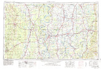
1953 Map of Greenwood
USGS Topo · Published 1980About this map
Mississippi River oxbows and the expansive alluvial plains of the Delta dominate this mid-century survey, capturing a landscape defined by its intricate water systems and rail-dependent economies. The map traces the winding paths of the Tallahatchie River and Sunflower River, which together with the Yazoo River created the fertile foundation for the region's agricultural hubs. Major centers like Greenville, Greenwood, and Indianola are shown at a time when the Illinois Central Railroad and Missouri Pacific Railroad provided the primary arteries for commerce and movement across state lines into Arkansas.
Find a feature on this map
213 named features on this map. Tap any name to fly to it.
Don’t see what you’re looking for? This feature index may not catch every label — zoom into the map to look around manually.
Map Details
Editions of this 1953 Greenwood Map
5 editions found

Other maps of this area

1909 · Wilsons Point
USGS Topo · 1:24,000

1909 · Millikin
USGS Topo · 1:24,000

1909 · Ashton Bridge
USGS Topo · 1:24,000

1912 · Ashton Bridge
USGS Topo · 1:31,680

1913 · Wilson Point
USGS Topo · 1:31,680

1930 · Mellwood
USGS Topo · 1:62,500

1931 · Schlater
USGS Topo · 1:48,000

1931 · Sumner
USGS Topo · 1:48,000

1931 · Drew
USGS Topo · 1:48,000

1932 · Philipp
USGS Topo · 1:48,000