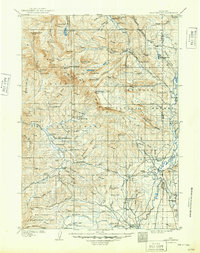
1910 Map of Gros Ventre
USGS Topo · Published 1949About this map
Gros Ventre River and the high basins of the Bridger National Forest define this landscape at the turn of the century. The map documents an era of early homesteading and ranching in western Wyoming, where family holdings like Robinson's Ranch, Lloyds Ranch, and Darwin's Ranch are scattered along the major waterways. The presence of the Twin Creek School and the Ranger's Cabin reflects the emerging infrastructure of a rural mountain community. This survey, conducted by E.C. Barnard, meticulously captures the transition from wilderness to managed forest land. From the high elevations of Darwin Peak to the Jack Creek Basin, the map traces the network of pack trails and early roads that connected remote outposts like Old Kendall and the Pfisterer Ranch.
Find a feature on this map
101 named features on this map. Tap any name to fly to it.
Don’t see what you’re looking for? This feature index may not catch every label — zoom into the map to look around manually.
Map Details
Editions of this 1910 Gros Ventre Map
3 editions found
Other maps of this area

1899 · Grand Teton
USGS Topo · 1:125,000

1901 · Grand Teton
USGS Topo · 1:125,000

1902 · Mt Leidy
USGS Topo · 1:125,000

1905 · Younts Peak
USGS Topo · 1:125,000

1907 · Younts Peak
USGS Topo · 1:125,000

1907 · Gros Ventre
USGS Topo · 1:125,000

1909 · Fremont Peak
USGS Topo · 1:125,000

1910 · Gros Ventre
USGS Topo · 1:125,000

1921 · Afton
USGS Topo · 1:125,000

1931 · Jackson
USGS Topo · 1:125,000