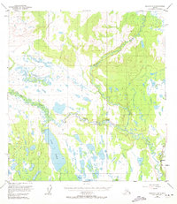
1950 Map of Gulkana C-4
USGS Topo · Published 1971About this map
The confluence of the Gulkana River and its West Fork Gulkana River dominates this interior Alaskan landscape, which was mapped from 1949 aerial photography. The Richardson Highway runs along the eastern edge of the sheet, providing the primary land route through the Copper River Meridian region. The settlement of Sourdough serves as the focal point for human activity in this area, situated near the mouth of Sourdough Creek. A public Campground near the river reflects the early development of recreational access along the highway corridor. Away from the road, the terrain is characterized by a complex network of wetlands and small water bodies, including Fish Lake, Middle Lake, and Boulder Lake, many of which were still unsurveyed by the Bureau of Land Management at the time of this study. This era of mapping reveals the landscape just before more intensive modern development altered the remote wilderness character of the Gulkana basin.
Find a feature on this map
10 named features on this map. Tap any name to fly to it.
Don’t see what you’re looking for? This feature index may not catch every label — zoom into the map to look around manually.
Map Details
Editions of this 1950 Gulkana C-4 Map
4 editions found
Other maps of this area

1949 · Gulkana D-3
USGS Topo · 1:63,360

1950 · Gulkana D-4
USGS Topo · 1:63,360

1950 · Gulkana B-3
USGS Topo · 1:63,360

1950 · Gulkana C-3
USGS Topo · 1:63,360

1950 · Gulkana C-4
USGS Topo · 1:63,360

1951 · Gulkana
USGS Topo · 1:250,000

1951 · Gulkana B-5
USGS Topo · 1:63,360

1951 · Gulkana D-5
USGS Topo · 1:63,360

1951 · Gulkana C-5
USGS Topo · 1:63,360

1951 · Gulkana B-4
USGS Topo · 1:63,360