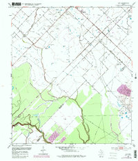
1953 Map of Guy
USGS Topo · Published 1981About this map
The Damon Mound Oil Field and the Needville Field define the economic character of this landscape at the intersection of Fort Bend, Brazoria, and Wharton counties. These petroleum operations are concentrated around the prominent geological feature Damon Mound, where dozens of oil wells and tanks suggest an era of intensive local production. The small settlement of Guy serves as a hub, complete with a Guy (Siding) along the Atchison Topeka and Santa Fe railroad, which parallels the Memorial Highway. In the agricultural reaches to the west, rural life is anchored by landmarks like New Prospect Ch, Routt Sch, and the Guy Cem. This 1953 survey, updated with later aerial data, captures the complex overlay of oil infrastructure atop a network of creeks like Buffalo Creek and Mound Creek that drain toward the San Bernard River.
Find a feature on this map
22 named features on this map. Tap any name to fly to it.
Don’t see what you’re looking for? This feature index may not catch every label — zoom into the map to look around manually.
Map Details
Editions of this 1953 Guy Map
4 editions found
Other maps of this area

1950 · Houston
USGS Topo · 1:250,000

1952 · West Columbia
USGS Topo · 1:24,000

1952 · Danciger
USGS Topo · 1:24,000

1952 · Pledger
USGS Topo · 1:24,000

1953 · Needville
USGS Topo · 1:24,000

1953 · Guy
USGS Topo · 1:24,000

1953 · Lake George
USGS Topo · 1:24,000

1953 · Kendleton
USGS Topo · 1:24,000

1953 · Damon
USGS Topo · 1:24,000

1953 · Boling
USGS Topo · 1:24,000