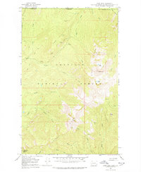
1967 Map of Gypsy Peak
USGS Topo · Published 1978About this map
Gypsy Ridge and the high summit of Gypsy Peak define this remote section of the Colville National Forest at the northern edge of the Selkirk Mountains. Surveyed in the late 1960s, the map documents a landscape of high-altitude resource extraction and fire surveillance along the United States Canada border. The Lead Hill Mine and scattered Prospects near Lead Hill point to the area's mineral interest, while the Lookout Tower Sullivan Mtn atop Sullivan Mtn represents the era's fire lookout network overseeing the drainage basins of Slate Creek and North Fork Sullivan Creek. A network of high-country routes including the Jeep Trail and Pack Trail provide the primary access to isolated landmarks like Bear Pasture and the Gypsy Lakes.
Find a feature on this map
37 named features on this map. Tap any name to fly to it.
Don’t see what you’re looking for? This feature index may not catch every label — zoom into the map to look around manually.
Map Details
Editions of this 1967 Gypsy Peak Map
3 editions found
Other maps of this area

1934 · Metaline
USGS Topo · 1:125,000

1942 · Metaline
USGS Topo · 1:125,000

1958 · Sandpoint
USGS Topo · 1:250,000

1963 · Sandpoint
USGS Topo · 1:250,000

1967 · Gypsy Peak
USGS Topo · 1:24,000

1967 · Boundary Dam
USGS Topo · 1:24,000

1967 · Salmo Mtn.
USGS Topo · 1:24,000

1967 · Metaline Falls
USGS Topo · 1:24,000

1967 · Helmer Mtn
USGS Topo · 1:24,000

1967 · Pass Creek
USGS Topo · 1:24,000