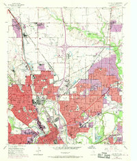
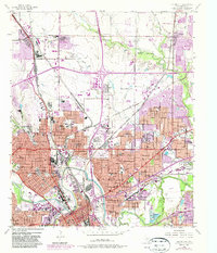
1955 Map of Haltom City
USGS Topo · Published 1969About this map
Fort Worth dominates the southwestern portion of this mid-century survey, revealing an urban landscape defined by industrial infrastructure and deep-rooted community markers. The convergence of the West Fork Trinity River and the Clear Fork Trinity River serves as a geographic anchor, flanked by major cemeteries like Mount Olivet Cemetery, Oakwood Cemetery, and Greenwood Cemetery. Rapid post-war suburbanization is evident in the burgeoning neighborhoods of Haltom City and Melody Hills, while the purple photorevisions from 1968 show the steady creep of development toward Watauga.
Find a feature on this map
90 named features on this map. Tap any name to fly to it.
Don’t see what you’re looking for? This feature index may not catch every label — zoom into the map to look around manually.
Map Details
Editions of this 1955 Haltom City Map
6 editions found
Other maps of this area

1894 · Fort Worth
USGS Topo · 1:125,000

1931 · Grapevine
USGS Topo · 1:62,500

1954 · Dallas
USGS Topo · 1:250,000

1955 · Haltom City
USGS Topo · 1:24,000

1955 · Avondale
USGS Topo · 1:24,000

1955 · Keller
USGS Topo · 1:24,000

1955 · Lake Worth
USGS Topo · 1:24,000

1955 · Benbrook
USGS Topo · 1:24,000

1955 · Fort Worth
USGS Topo · 1:24,000

1955 · Haltom City
USGS Topo · 1:62,500