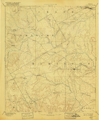
1894 Map of Hamilton
USGS Topo · Published 1918About this map
The Leon River and its numerous tributaries dominate this late-19th-century landscape, reflecting a time when water access and reliable crossings dictated the location of central Texas settlements. Hamilton serves as the primary hub, surrounded by smaller dispersed communities like Siloam, Pottsville, and Indian Gap. In the far northeast corner, the Texas Central Railroad cuts across the Bosque River, providing a vital industrial link to the region's ranching and agricultural economy. The map reveals the intricate network of wagon roads connecting isolated post offices and mills, such as Gentry Mill and Hazle Dell. Topographical landmarks like the Hoover Knobs provided early travelers with navigational points across the undulating terrain between the Leon and the Lampasas River in the south. This record preserves the early footprint of Hamilton, Comanche, and Erath counties before the modern highway system restructured the local landscape.
Find a feature on this map
47 named features on this map. Tap any name to fly to it.
Don’t see what you’re looking for? This feature index may not catch every label — zoom into the map to look around manually.
Map Details
Editions of this 1894 Hamilton Map
5 editions found
Other maps of this area

1885 · San Saba
USGS Topo · 1:125,000

1887 · Lampasas
USGS Topo · 1:125,000

1888 · Hamilton
USGS Topo · 1:125,000

1888 · Meridian
USGS Topo · 1:125,000

1889 · Granbury
USGS Topo · 1:125,000

1889 · Brownwood
USGS Topo · 1:125,000

1890 · Stephenville
USGS Topo · 1:125,000

1894 · Hamilton
USGS Topo · 1:125,000

1894 · Meridian
USGS Topo · 1:125,000

1894 · Lampasas
USGS Topo · 1:125,000