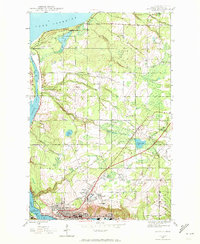
1946 Map of Hancock
USGS Topo · Published 1972About this map
The industrial and maritime heart of Michigan’s Copper Country is revealed in this post-war survey of Hancock and its surrounding mining townships. The topography is dominated by the steep ascent from the Portage Lake Ship Canal to the high plateaus of Arcadian Hill, where the Franklin Mine and settlements like Lower Pewabic and Paavola sit atop the mineral-rich Keweenaw fault. This area serves as a critical junction for three major rail lines—the Duluth South Shore and Atlantic, the Mineral Range, and the Copper Range—which once moved massive quantities of copper ore toward the lakeside stamp mills.
Find a feature on this map
36 named features on this map. Tap any name to fly to it.
Don’t see what you’re looking for? This feature index may not catch every label — zoom into the map to look around manually.
Map Details
Editions of this 1946 Hancock Map
5 editions found
Other maps of this area

1915 · Houghton
USGS Topo · 1:62,500

1941 · Ahmeek
USGS Topo · 1:31,680

1946 · Hancock
USGS Topo · 1:24,000

1946 · Chassell
USGS Topo · 1:24,000

1946 · South Range
USGS Topo · 1:24,000

1946 · Muggun Creek
USGS Topo · 1:24,000

1946 · Ahmeek
USGS Topo · 1:24,000

1946 · Laurium
USGS Topo · 1:24,000

1947 · Ahmeek
USGS Topo · 1:24,000

1948 · South Range
USGS Topo · 1:24,000