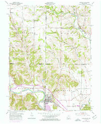
1955 Map of Harrison
USGS Topo · Published 1976About this map
The Whitewater River and its major tributary, the Johnson Fork, define the landscape of this border region where Ohio and Indiana meet. This survey shows the town of Harrison and its neighbor West Harrison during a period of transition, with purple overlays reflecting expansion around the historic core and the Harrison Airport. The map is particularly valuable for genealogical research, documenting numerous rural burying grounds such as Otwell Cem, Fairview Cem, and Harrison Hills Cem, many associated with early crossroads settlements like Drewersburg and Macedonia. Transportation networks are well-detailed, showing the Penn Central rail line following the river valley alongside the Harrison Pike. North of the more developed southern valley, the terrain rises into hills like Snow Hill, where smaller communities like Rockdale and Alert remain isolated among the creeks and runs.
Find a feature on this map
63 named features on this map. Tap any name to fly to it.
Don’t see what you’re looking for? This feature index may not catch every label — zoom into the map to look around manually.
Map Details
Editions of this 1955 Harrison Map
5 editions found

Other maps of this area

1914 · West Cincinnati
USGS Topo · 1:62,500

1915 · Lawrenceburg
USGS Topo · 1:48,000

1915 · Harrison
USGS Topo · 1:48,000

1915 · Hamilton
USGS Topo · 1:62,500

1917 · Hamilton
USGS Topo · 1:62,500

1928 · Lawrenceburg
USGS Topo · 1:62,500

1932 · Lawrenceburg
USGS Topo · 1:62,500

1943 · Hooven
USGS Topo · 1:24,000

1943 · Guilford
USGS Topo · 1:24,000

1953 · Guilford
USGS Topo · 1:24,000