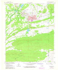
1967 Map of Hartshorne
USGS Topo · Published 1978About this map
The industrial and transportation corridor along the Chicago Rock Island and Pacific railroad defines this portion of the Oklahoma coal belt. Adjacent settlements of Haileyville and Hartshorne appear with their dense street grids, including landmarks like the High Sch, Armory, and City Hall. The landscape is characterized by sharp topographic transitions, where the developed valley floor is bounded by the steep, forested slopes of Limestone Ridge and Blue Mountain. Cultural history is well-represented through several burial grounds, including Elmwood Cemetery and Elm Park Cem, along with rural identifiers like the Lone Oak Sch. Water management for the growing community is evident in the presence of Hartshorne Lake and various Sewage Disp Ponds. To the north, the smaller community of Dow sits near Dow Lake, while the eastern portion of the sheet transitions toward Number Ten Mountain at the Pittsburg Co and Latimer Co boundary.
Find a feature on this map
38 named features on this map. Tap any name to fly to it.
Don’t see what you’re looking for? This feature index may not catch every label — zoom into the map to look around manually.
Map Details
Editions of this 1967 Hartshorne Map
2 editions found

Other maps of this area

1898 · McAlester
USGS Topo · 1:125,000

1901 · Tuskahoma
USGS Topo · 1:125,000

1908 · Tuskahoma
USGS Topo · 1:125,000

1909 · Mc Alester
USGS Topo · 1:125,000

1909 · Tuskahoma
USGS Topo · 1:125,000

1950 · Mcalester
USGS Topo · 1:250,000

1962 · McAlester
USGS Topo · 1:250,000

1965 · McAlester
USGS Topo · 1:250,000

1967 · Krebs
USGS Topo · 1:24,000
1967 · Adamson
USGS Topo · 1:24,000