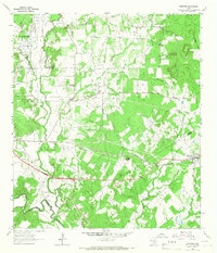
1964 Map of Harwood
USGS Topo · Published 1966About this map
The Salt Flat Oil Field dominates the northwestern corner of this Texas landscape, illustrating the industrial footprint of petroleum extraction in the mid-1960s. The settlement of Harwood serves as a local hub along the Southern Pacific tracks, while the rural character of the surrounding area is defined by family-named cemeteries and small clusters of activity like Soda Springs and Mc Neil. To the south, the San Marcos River and Plum Creek carve through the terrain, joined by an Old Railroad Grade that hints at earlier transportation networks. Distinctive elevations like Iron Peak and Iron Mountain provide landmarks amidst a web of drainage features including Salt Branch and Mc Neil Creek. This survey captures the transition from cattle country to oil territory, marked by extensive pipelines and gravel pits that underscore the region's resource-driven economy.
Find a feature on this map
28 named features on this map. Tap any name to fly to it.
Don’t see what you’re looking for? This feature index may not catch every label — zoom into the map to look around manually.
Map Details
Editions of this 1964 Harwood Map
3 editions found
Other maps of this area

1901 · Flatonia
USGS Topo · 1:125,000

1911 · San Marcos
USGS Topo · 1:125,000

1919 · San Marcos
USGS Topo · 1:125,000

1925 · San Marcos 4-c
USGS Topo · 1:48,000

1925 · San Marcos 1-d
USGS Topo · 1:48,000

1925 · San Marcos 4-a
USGS Topo · 1:48,000

1929 · Luling
USGS Topo · 1:62,500

1930 · Lockhart
USGS Topo · 1:62,500

1953 · Seguin
USGS Topo · 1:250,000

1958 · Seguin
USGS Topo · 1:250,000