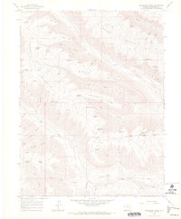
1964 Map of Henderson Ridge
USGS Topo · Published 1968About this map
Brush Mountain and the high elevations of Horse Ridge dominate this mid-1960s survey of the Colorado backcountry. The landscape is defined by its verticality, where prominent features like Bear Point and Chimney Rock Point overlook a network of seasonal water sources such as Elk Horn Spring and Poverty Spring. Human presence is sparse, marked primarily by the Altenbern Ranch and the isolated Middle Ranch, suggesting a region primarily utilized for livestock grazing.
Find a feature on this map
58 named features on this map. Tap any name to fly to it.
Don’t see what you’re looking for? This feature index may not catch every label — zoom into the map to look around manually.
Map Details
Editions of this 1964 Henderson Ridge Map
3 editions found
Other maps of this area

1929 · Highmore
USGS Topo · 1:62,500

1929 · Roan Creek
USGS Topo · 1:62,500

1956 · Grand Junction
USGS Topo · 1:250,000

1959 · Grand Junction
USGS Topo · 1:250,000

1960 · Grand Junction
USGS Topo · 1:250,000

1962 · Grand Junction
USGS Topo · 1:250,000

1964 · Grand Junction
USGS Topo · 1:250,000

1964 · Brushy Point
USGS Topo · 1:24,000

1964 · Henderson Ridge
USGS Topo · 1:24,000

1964 · Calf Canyon
USGS Topo · 1:24,000