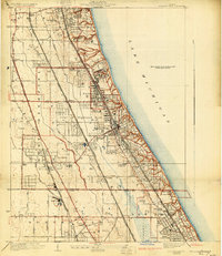
1928 Map of Highland Park
USGS Topo · Published 1930About this map
Fort Sheridan stands as a prominent military installation on the bluff overlooking Lake Michigan, anchoring a landscape defined by North Shore suburbanization and elite recreational development. This late 1920s survey captures the intense concentration of private estates and country clubs, such as the Onwentsia Club and Exmoor Country Club, which replaced the earlier agricultural character of Shields and Deerfield townships. The transportation backbone is clearly visible, with the Chicago North Shore and Milwaukee Railroad and the Chicago and Northwestern Railway running parallel to the coast, facilitating the growth of the City of Highland Park and Lake Forest. Beyond the residential corridors, the map reveals the industrial legacy of the area at the Brickyard near the North Branch Chicago River, and the cultural significance of Ravinia Park, already a destination for music and the arts.
Find a feature on this map
51 named features on this map. Tap any name to fly to it.
Don’t see what you’re looking for? This feature index may not catch every label — zoom into the map to look around manually.
Map Details
Editions of this 1928 Highland Park Map
4 editions found
Other maps of this area

1899 · Evanston
USGS Topo · 1:62,500

1900 · Highwood
USGS Topo · 1:62,500

1906 · Waukegan
USGS Topo · 1:62,500

1908 · Waukegan
USGS Topo · 1:62,500

1927 · Arlington Heights
USGS Topo · 1:24,000

1928 · Wheeling
USGS Topo · 1:24,000

1928 · Highland Park
USGS Topo · 1:24,000

1928 · Evanston
USGS Topo · 1:24,000

1929 · Park Ridge
USGS Topo · 1:24,000

1951 · Highland Park
USGS Topo · 1:24,000