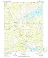
1981 Map of Hobart Mills
USGS Topo · Published 1986About this map
The settlement of Hobart Mills anchors this landscape within the Tahoe National Forest, documenting a region defined by its timber and water resources during the late 20th century. Industrial history is visible in the identification of the Old Smith Mill (Site) and the Winnie Smith Mill (Site), marking the locations of former milling operations. The map details a complex hydrological network, including the Little Truckee River and Sagehen Creek, which feed into the significant impoundments of Stampede Reservoir and Prosser Creek Reservoir. These reservoirs, managed by the Bureau of Reclamation, are flanked by public recreation sites like Lakeside Campground and Prosser Campground. Research activity is noted at the Univ of Calif Wildlife Exper Sta near the Sagehen Hills, while the inclusion of sites like Woodchoppers Spring and Kyburz Flat provides specific points of interest for local history and genealogy research.
Find a feature on this map
38 named features on this map. Tap any name to fly to it.
Don’t see what you’re looking for? This feature index may not catch every label — zoom into the map to look around manually.
Map Details
Editions of this 1981 Hobart Mills Map
3 editions found
Other maps of this area

1890 · Sierraville
USGS Topo · 1:125,000

1891 · Truckee
USGS Topo · 1:125,000

1892 · Sierraville
USGS Topo · 1:125,000

1893 · Truckee
USGS Topo · 1:125,000

1894 · Sierraville
USGS Topo · 1:125,000

1895 · Truckee
USGS Topo · 1:125,000

1932 · Truckee
USGS Topo · 1:96,000

1940 · Truckee
USGS Topo · 1:125,000

1955 · Truckee
USGS Topo · 1:24,000

1955 · Loyalton
USGS Topo · 1:62,500