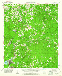
1953 Map of Hodge
USGS Topo · Published 1961About this map
The Chicago Rock Island and Pacific railroad forms the industrial backbone of this North Louisiana landscape, connecting the mills and industry of Hodge and Jonesboro with smaller settlements like Ansley and Quitman. In the early 1950s, the rural character of Jackson and Lincoln Parishes is defined by a dense network of country churches and schools, such as China Grove Sch and Saints Rest Sch. The terrain is marked by numerous family-named hills and branches, with the Dugdemona River and its various tributaries like Cypress Creek and Little River draining the piney woods. Significant local landmarks include the Vernon Lookout Tower and smaller communities such as Punkin Center and Rockfield. The abundance of cemeteries, including Wesley Chapel Cem and St Clair Cem, provides valuable points of interest for genealogists tracing family roots through these established rural parishes.
Find a feature on this map
73 named features on this map. Tap any name to fly to it.
Don’t see what you’re looking for? This feature index may not catch every label — zoom into the map to look around manually.
Map Details
Editions of this 1953 Hodge Map
5 editions found

Other maps of this area

1947 · Goldonna
USGS Topo · 1:62,500

1947 · Bienville
USGS Topo · 1:62,500

1949 · Bienville
USGS Topo · 1:62,500

1949 · Jonesboro
USGS Topo · 1:62,500

1950 · Jonesboro
USGS Topo · 1:62,500

1950 · Ruston
USGS Topo · 1:62,500

1950 · Arcadia
USGS Topo · 1:62,500

1951 · Arcadia
USGS Topo · 1:62,500

1951 · Ruston
USGS Topo · 1:62,500

1952 · Calhoun
USGS Topo · 1:62,500