
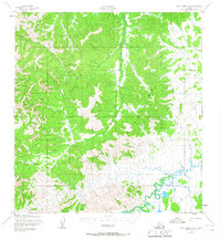
1952 Map of Holy Cross A-4
USGS Topo · Published 1959About this map
Stuyahok serves as the primary focal point of this 1950s interior landscape, situated at the confluence of several resource-extraction and transportation markers. The map details the local industrial footprint through the Stuyahok Mine and a nearby Airstrip, indicating the region's reliance on aerial access for remote operations. The winding Stuyahok River and Mountain Creek cut through the prominent Kilbuck Mountains, which dominate the topographic relief. A documented Winter Trail provides a grounded look at the seasonal transit routes used before more permanent infrastructure reached this part of the territory. To the southeast, the terrain softens toward the water system at Tuckers Slough, illustrating the transition from high-elevation mining country to the lower riparian wetlands.
Find a feature on this map
8 named features on this map. Tap any name to fly to it.
Don’t see what you’re looking for? This feature index may not catch every label — zoom into the map to look around manually.
Map Details
Editions of this 1952 Holy Cross A-4 Map
3 editions found

Other maps of this area

1947 · Russian Mission
USGS Topo · 1:250,000

1950 · Russian Mission
USGS Topo · 1:250,000

1951 · Holy Cross
USGS Topo · 1:250,000

1951 · Holy Cross A-5
USGS Topo · 1:63,360

1952 · Holy Cross B-3
USGS Topo · 1:63,360

1952 · Holy Cross B-5
USGS Topo · 1:63,360

1952 · Holy Cross A-3
USGS Topo · 1:63,360

1952 · Holy Cross B-4
USGS Topo · 1:63,360

1952 · Holy Cross
USGS Topo · 1:250,000

1952 · Russian Mission D-4
USGS Topo · 1:63,360