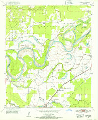
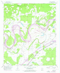
1951 Map of Homan
USGS Topo · Published 1952About this map
The Red River meanders through the heart of this 1951 survey, creating a complex network of oxbows and sloughs along the border of Miller and Little River counties. The landscape is defined by its riparian geometry, with named features like Cut-off Lake, Old River Lake, and Crystal Lake revealing the shifting course of the water. On the higher ground of the Homan township, the Missouri Pacific railroad anchors the settlement of Homan, which serves as a focal point for the surrounding rural community. Local life in this era is mapped through its small landmarks, including the Paup Cem and scattered rural congregations such as Swan Lake Ch, Lone Star Ch, and Gold Point Ch. These sites, along with the Clear Lake Junction, illustrate a mid-century Arkansas river valley where transport and tradition were tied closely to the fertile but unpredictable floodplains of the McKinney Bayou and Bois d'Arc Bayou.
Find a feature on this map
30 named features on this map. Tap any name to fly to it.
Don’t see what you’re looking for? This feature index may not catch every label — zoom into the map to look around manually.
Map Details
Editions of this 1951 Homan Map
6 editions found
Other maps of this area

1909 · Texarkana
USGS Topo · 1:62,500

1950 · Ashdown East
USGS Topo · 1:24,000

1950 · Ogden
USGS Topo · 1:24,000

1950 · Red Bluff
USGS Topo · 1:24,000

1951 · Ogden
USGS Topo · 1:24,000

1951 · Red Bluff
USGS Topo · 1:24,000

1951 · Ashdown East
USGS Topo · 1:24,000

1951 · Homan
USGS Topo · 1:24,000

1951 · Fulton
USGS Topo · 1:24,000

1951 · Mc Nab
USGS Topo · 1:24,000