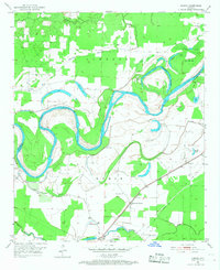
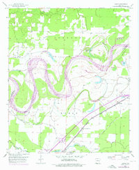
1951 Map of Homan
USGS Topo · Published 1968About this map
The Red River dominates this mid-century landscape, carving deep oxbows and leave-behind lakes across the Miller County river bottom. The river's winding path creates a complex network of wetlands and sloughs, including Cut-off Lake, Old River Lake, and Horseshoe Lake, which mark the former channels of the migrating waterway. Human activity is concentrated along the higher ground and the Missouri Pacific railroad corridor, where the settlement of Homan serves as a local hub. Rural life is anchored by community landmarks such as Lone Star Ch, Swan Lake Ch, and the Paup Cem. A sophisticated system of levees and drainage projects like Gillespie Ditch reveal the 1950s efforts to manage the flood-prone fertile lands between McKinney Bayou and the main river channel.
Find a feature on this map
33 named features on this map. Tap any name to fly to it.
Don’t see what you’re looking for? This feature index may not catch every label — zoom into the map to look around manually.
Map Details
Editions of this 1951 Homan Map
6 editions found
Other maps of this area

1909 · Texarkana
USGS Topo · 1:62,500

1950 · Ashdown East
USGS Topo · 1:24,000

1950 · Ogden
USGS Topo · 1:24,000

1950 · Red Bluff
USGS Topo · 1:24,000

1951 · Ogden
USGS Topo · 1:24,000

1951 · Red Bluff
USGS Topo · 1:24,000

1951 · Ashdown East
USGS Topo · 1:24,000

1951 · Homan
USGS Topo · 1:24,000

1951 · Fulton
USGS Topo · 1:24,000

1951 · Mc Nab
USGS Topo · 1:24,000