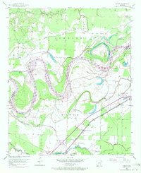
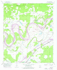
1951 Map of Homan
USGS Topo · Published 1972About this map
The Red River dominates this Miller County landscape, its meandering path defined by a series of oxbows and abandoned channels like Old River Lake, Cut-off Lake, and Young Lake. This survey, based on 1951 fieldwork with 1970 revisions, highlights the extensive Levee systems and drainage infrastructure required to manage the flood-prone bottomlands. Settlement is concentrated along the Missouri Pacific railroad line, which runs through the community of Homan and past Clear Lake Junction in the southeast.
Find a feature on this map
31 named features on this map. Tap any name to fly to it.
Don’t see what you’re looking for? This feature index may not catch every label — zoom into the map to look around manually.
Map Details
Editions of this 1951 Homan Map
6 editions found
Other maps of this area

1909 · Texarkana
USGS Topo · 1:62,500

1950 · Ashdown East
USGS Topo · 1:24,000

1950 · Ogden
USGS Topo · 1:24,000

1950 · Red Bluff
USGS Topo · 1:24,000

1951 · Ogden
USGS Topo · 1:24,000

1951 · Red Bluff
USGS Topo · 1:24,000

1951 · Ashdown East
USGS Topo · 1:24,000

1951 · Homan
USGS Topo · 1:24,000

1951 · Fulton
USGS Topo · 1:24,000

1951 · Mc Nab
USGS Topo · 1:24,000