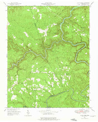
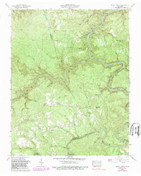
1952 Map of Honey Creek
USGS Topo · Published 1975About this map
The South Fork Cumberland River carves a deep path through this 1952 topographic study, where the border of Scott and Fentress counties is defined by the winding course of Clear Fork and other major tributaries. The Oneida and Western railroad tracks follow the river's edge, serving small riverside settlements like Zenith and Gernt. This era shows a landscape transitioning from heavy industrial dependence on the rails to a scattered rural community infrastructure, evidenced by several small churches and schools serving the high ground of Hurricane Ridge.
Find a feature on this map
51 named features on this map. Tap any name to fly to it.
Don’t see what you’re looking for? This feature index may not catch every label — zoom into the map to look around manually.
Map Details
Editions of this 1952 Honey Creek Map
6 editions found
Other maps of this area

1895 · Wartburg
USGS Topo · 1:125,000

1896 · Wartburg
USGS Topo · 1:125,000

1934 · Barthell
USGS Topo · 1:62,500

1934 · Pall Mall
USGS Topo · 1:62,500

1952 · Helenwood
USGS Topo · 1:24,000

1952 · Honey Creek
USGS Topo · 1:24,000

1952 · Rugby
USGS Topo · 1:24,000
1952 · Robbins
USGS Topo · 1:24,000

1954 · Stockton
USGS Topo · 1:24,000

1954 · Burrville
USGS Topo · 1:24,000