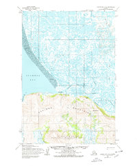
1952 Map of Hooper Bay D-2
USGS Topo · Published 1978About this map
Scammon Bay serves as a focal point along the coastline of the Yukon-Kuskokwim Delta, where the sea meets a landscape defined by extensive tidal flats and the prominent As Kinuk Mountains. In the early 1950s, this area supported seasonal and permanent activity evidenced by the Seaplane Base and scattered Cabins. The intricate waterways, including the Kun River and Ear River, weave through vast stretches of Sand and Mud, creating a complex deltaic environment within the Clarence Rhode National Wildlife Range.
Find a feature on this map
19 named features on this map. Tap any name to fly to it.
Don’t see what you’re looking for? This feature index may not catch every label — zoom into the map to look around manually.
Map Details
Editions of this 1952 Hooper Bay D-2 Map
2 editions found
Other maps of this area

1951 · Hooper Bay
USGS Topo · 1:250,000

1951 · Black
USGS Topo · 1:250,000

1952 · Black A-2
USGS Topo · 1:63,360

1952 · Black A-1
USGS Topo · 1:63,360

1952 · Hooper Bay C-3
USGS Topo · 1:63,360
1952 · Hooper Bay D-1
USGS Topo · 1:63,360
1952 · Hooper Bay C-1
USGS Topo · 1:63,360

1952 · Hooper Bay D-2
USGS Topo · 1:63,360

1953 · Hooper Bay
USGS Topo · 1:250,000

1953 · Hooper Bay C-2
USGS Topo · 1:63,360