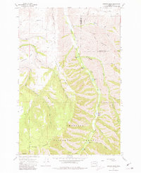
1967 Map of Hopkins Ridge
USGS Topo · Published 1981About this map
Hopkins Ridge divides the drainages of the Blue Mountains, where steep canyons and high ridges define the boundary between Columbia and Garfield counties. The Tucannon River flows northward through the center of the sheet, supporting a string of recreational and conservation sites including Spring Lake, Rainbow Lake, and Watson Lake. A Fish Hatchery and the Tucannon Guard Sta represent the infrastructure of the Umatilla National Forest in the late 1960s. The landscape is marked by a transition from the agricultural high ground near a small Cem and Gravel Pit in the northwest corner to the deeply incised valleys of North Patit Creek and Cummings Creek. Numerous jeep trails snake along the sharp ridgelines of Maloney Mountain and Linville Ridge, providing access to this high-elevation terrain.
Find a feature on this map
29 named features on this map. Tap any name to fly to it.
Don’t see what you’re looking for? This feature index may not catch every label — zoom into the map to look around manually.
Map Details
Editions of this 1967 Hopkins Ridge Map
4 editions found
Other maps of this area

1937 · Pomeroy
USGS Topo · 1:96,000

1942 · Pomeroy
USGS Topo · 1:125,000

1955 · Pullman
USGS Topo · 1:250,000

1958 · Pullman
USGS Topo · 1:250,000

1967 · Rose Springs
USGS Topo · 1:24,000

1967 · Hopkins Ridge
USGS Topo · 1:24,000

1967 · Cahill Mtn
USGS Topo · 1:24,000
1967 · Pomeroy
USGS Topo · 1:24,000

1967 · Stentz Spring
USGS Topo · 1:24,000

1967 · Turner
USGS Topo · 1:24,000