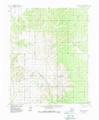
1956 Map of Hughes A-2
USGS Topo · Published 1988About this map
Indian Mountain serves as the dominant topographic landmark in this mid-century Alaskan interior survey, presiding over a landscape defined by the drainages of the Indian River and Slathlouka Creek. The map records essential transportation and extractive activity in a region where travel depended on the Sled Trail and a strategically placed Landing Strip. The presence of a Placer Mine along a tributary of the Indian River points to the small-scale gold mining operations that shaped local exploration and industry during this era. Surveyed in the 1950s using aerial photography, the sheet also details significant elevations such as VABM 2983 Menta and Vabm 4234, which provided critical geodetic control for the Geological Survey. Numerous seasonal and perennial waterways like Fish Creek, Atla Creek, and Notoniono Creek weave through the unsurveyed land lines predetermined by the Bureau of Land Management.
Find a feature on this map
15 named features on this map. Tap any name to fly to it.
Don’t see what you’re looking for? This feature index may not catch every label — zoom into the map to look around manually.
Map Details
Editions of this 1956 Hughes A-2 Map
3 editions found
Other maps of this area

1951 · Hughes
USGS Topo · 1:250,000

1951 · Melozitna
USGS Topo · 1:250,000

1952 · Melozitna D-1
USGS Topo · 1:63,360

1952 · Melozitna D-3
USGS Topo · 1:63,360

1954 · Melozitna D-3
USGS Topo · 1:63,360

1955 · Melozitna D-2
USGS Topo · 1:63,360

1955 · Hughes A-2
USGS Topo · 1:63,360

1955 · Hughes A-1
USGS Topo · 1:63,360

1955 · Hughes A-3
USGS Topo · 1:63,360

1956 · Hughes
USGS Topo · 1:250,000