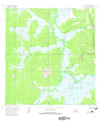
1954 Map of Iditarod B-5
USGS Topo · Published 1983About this map
Flat stands as a focal point in the northeast corner of this mid-century Alaskan interior survey, marking a site of gold-mining activity where a Placer Mine and a Cem are recorded. The landscape is defined by the winding course of the Iditarod River, which snakes through the marshy expanse of Bonanza Flats. To the south, the prominent elevation of Swinging Dome rises above a network of waterways including Fairbanks Creek and Bonanza Creek.
Find a feature on this map
22 named features on this map. Tap any name to fly to it.
Don’t see what you’re looking for? This feature index may not catch every label — zoom into the map to look around manually.
Map Details
Editions of this 1954 Iditarod B-5 Map
3 editions found
Other maps of this area

1951 · Iditarod
USGS Topo · 1:250,000

1954 · Iditarod A-6
USGS Topo · 1:63,360

1954 · Iditarod A-5
USGS Topo · 1:63,360

1954 · Iditarod C-4
USGS Topo · 1:63,360

1954 · Iditarod A-4
USGS Topo · 1:63,360

1954 · Iditarod B-5
USGS Topo · 1:63,360

1954 · Iditarod C-5
USGS Topo · 1:63,360
1954 · Iditarod C-6
USGS Topo · 1:63,360

1954 · Iditarod B-4
USGS Topo · 1:63,360
1954 · Iditarod B-6
USGS Topo · 1:63,360