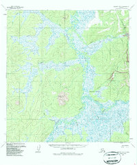
1954 Map of Iditarod B-5
USGS Topo · Published 1987About this map
The Iditarod River meanders through an intricate network of wetlands and tundra in this mid-century portrait of interior Alaska. The landscape is defined by its gold-mining legacy, evidenced by a Tramway (Aband) and a Placer Mine situated near the confluence of Happy Creek and Willow Creek. These industrial markers, alongside scattered Cabins and a lone Cem, suggest a period of transition as remote extractive sites were being reclaimed by the wild.
Find a feature on this map
19 named features on this map. Tap any name to fly to it.
Don’t see what you’re looking for? This feature index may not catch every label — zoom into the map to look around manually.
Map Details
Editions of this 1954 Iditarod B-5 Map
3 editions found
Other maps of this area

1951 · Iditarod
USGS Topo · 1:250,000

1954 · Iditarod A-6
USGS Topo · 1:63,360

1954 · Iditarod A-5
USGS Topo · 1:63,360

1954 · Iditarod C-4
USGS Topo · 1:63,360

1954 · Iditarod A-4
USGS Topo · 1:63,360

1954 · Iditarod B-5
USGS Topo · 1:63,360

1954 · Iditarod C-5
USGS Topo · 1:63,360
1954 · Iditarod C-6
USGS Topo · 1:63,360

1954 · Iditarod B-4
USGS Topo · 1:63,360
1954 · Iditarod B-6
USGS Topo · 1:63,360