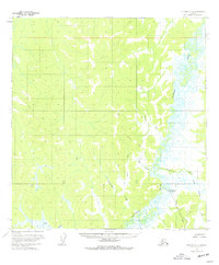
1954 Map of Iditarod C-5
USGS Topo · Published 1977About this map
The Iditarod (Aband'd) townsite sits along the winding course of the Iditarod River, marking a point of transition in the Alaskan interior after the peak of the gold rush era. By the mid-1950s, the landscape reflected a shift from active commerce to a quieter, post-extraction state, evidenced by the presence of a lone Mine and an abandoned Tramway (Aband'd) near the riverbank. This survey illustrates the intricate drainage network of the region, where numerous waterways such as Franklin Creek, Julie Creek, and Zimmerman Creek feed into the main river valley.
Find a feature on this map
13 named features on this map. Tap any name to fly to it.
Don’t see what you’re looking for? This feature index may not catch every label — zoom into the map to look around manually.
Map Details
Editions of this 1954 Iditarod C-5 Map
3 editions found
Other maps of this area

1951 · Iditarod
USGS Topo · 1:250,000

1954 · Iditarod D-6
USGS Topo · 1:63,360

1954 · Iditarod C-4
USGS Topo · 1:63,360

1954 · Iditarod B-5
USGS Topo · 1:63,360

1954 · Iditarod C-5
USGS Topo · 1:63,360
1954 · Iditarod C-6
USGS Topo · 1:63,360

1954 · Iditarod D-5
USGS Topo · 1:63,360

1954 · Iditarod B-4
USGS Topo · 1:63,360

1954 · Iditarod D-4
USGS Topo · 1:63,360
1954 · Iditarod B-6
USGS Topo · 1:63,360