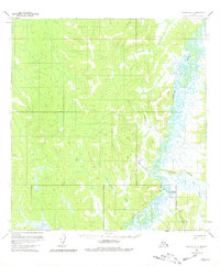
1954 Map of Iditarod C-5
USGS Topo · Published 1981About this map
The Iditarod (Aban'd) settlement sits as a quiet focal point along the winding Iditarod River in this mid-1950s interior Alaska survey. The landscape is defined by the complex, meandering river channel and its numerous oxbows, which serve as the primary artery through this territory. A legacy of the region's mining and transport history is visible in the decommissioned Tramway (Aban'd) and the overland Winter Trail, which together illustrate the difficulty of movement across this terrain before modern infrastructure. Numerous tributaries flow into the main river, including Franklin Creek, Belle Creek, and Zimmerman Creek, carving paths through the unnamed hills. This map documents a transition period where early 20th-century gold rush infrastructure had largely fallen into disuse, leaving behind the traces of industrial efforts in the wilderness.
Find a feature on this map
16 named features on this map. Tap any name to fly to it.
Don’t see what you’re looking for? This feature index may not catch every label — zoom into the map to look around manually.
Map Details
Editions of this 1954 Iditarod C-5 Map
3 editions found
Other maps of this area

1951 · Iditarod
USGS Topo · 1:250,000

1954 · Iditarod D-6
USGS Topo · 1:63,360

1954 · Iditarod C-4
USGS Topo · 1:63,360

1954 · Iditarod B-5
USGS Topo · 1:63,360

1954 · Iditarod C-5
USGS Topo · 1:63,360
1954 · Iditarod C-6
USGS Topo · 1:63,360

1954 · Iditarod D-5
USGS Topo · 1:63,360

1954 · Iditarod B-4
USGS Topo · 1:63,360

1954 · Iditarod D-4
USGS Topo · 1:63,360
1954 · Iditarod B-6
USGS Topo · 1:63,360