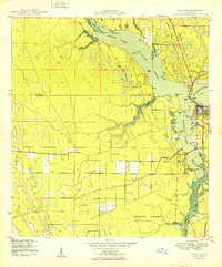
1953 Map of Indian Town
USGS Topo · Published 1969About this map
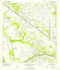
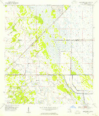
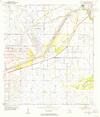
The Allapattah Flats dominate this landscape, illustrating the intricate drainage and water management systems of southern Florida in the early 1950s. The settlement of Indian Town serves as a central hub, situated where the Seaboard Air Line railroad intersects with vital water routes. This transit network is defined by the Okeechobee Waterway and the St Lucie Canal, both of which are lined with numerous Spoil Banks and protected by a Levee. A local Landing Field adjacent to the rail line highlights the area's mid-century role in regional transport. The map documents a landscape in transition, where vast wetlands are being systematically modified by a series of canals and dikes designed to control the flow of water across Martin County.
Find a feature on this map
10 named features on this map. Tap any name to fly to it.
Don’t see what you’re looking for? This feature index may not catch every label — zoom into the map to look around manually.
Map Details
Editions of this 1953 Indian Town Map
4 editions found
Other maps of this area

1948 · Palm City
USGS Topo · 1:24,000
1950 · Palm City
USGS Topo · 1:24,000
1953 · Okeechobee 4 SE
USGS Topo · 1:24,000
1953 · Okeechobee 4 NE
USGS Topo · 1:24,000
1953 · Indian Town SE
USGS Topo · 1:24,000

1953 · Indian Town NW
USGS Topo · 1:24,000

1953 · Indian Town
USGS Topo · 1:24,000

1956 · West Palm Beach
USGS Topo · 1:250,000

1956 · Fort Pierce
USGS Topo · 1:250,000

1957 · West Palm Beach
USGS Topo · 1:250,000