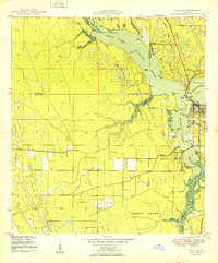
1953 Map of Indiantown
USGS Topo · Published 1983About this map
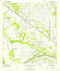
Indiantown serves as the central hub of this Martin County landscape, where the Seaboard railroad corridor meets a significant network of engineered water management. The town's grid is anchored by these transit lines, while the surrounding area is defined by the St Lucie Canal and the Okeechobee Waterway, which maintain a Project Depth 8 Feet for regional navigation.
Find a feature on this map
13 named features on this map. Tap any name to fly to it.
Don’t see what you’re looking for? This feature index may not catch every label — zoom into the map to look around manually.
Map Details
Editions of this 1953 Indiantown Map
4 editions found
Other maps of this area

1948 · Palm City
USGS Topo · 1:24,000
1950 · Palm City
USGS Topo · 1:24,000
1953 · Okeechobee 4 SE
USGS Topo · 1:24,000
1953 · Okeechobee 4 NE
USGS Topo · 1:24,000
1953 · Indian Town SE
USGS Topo · 1:24,000

1953 · Indian Town NW
USGS Topo · 1:24,000

1953 · Indian Town
USGS Topo · 1:24,000

1956 · West Palm Beach
USGS Topo · 1:250,000

1956 · Fort Pierce
USGS Topo · 1:250,000

1957 · West Palm Beach
USGS Topo · 1:250,000