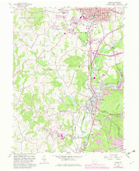
1963 Map of Indiana
USGS Topo · Published 1982About this map
Indiana serves as the regional hub in this early 1960s study, displaying a dense urban grid centered on the courthouse and Philadelphia Street. The landscape surrounding the borough is heavily influenced by the presence of the Pennsylvania Railroad and the Baltimore and Ohio lines, which connect the central town to specialized industrial and residential pockets. Notable heritage sites include the St Louis Ch (Slovak) and several family cemeteries such as Smathers Cem and Kunkle Cem, providing vital clues for genealogical research in Indiana County.
Find a feature on this map
65 named features on this map. Tap any name to fly to it.
Don’t see what you’re looking for? This feature index may not catch every label — zoom into the map to look around manually.
Map Details
Editions of this 1963 Indiana Map
4 editions found
Other maps of this area

1900 · Latrobe
USGS Topo · 1:62,500

1902 · Latrobe
USGS Topo · 1:62,500

1902 · Indiana
USGS Topo · 1:62,500

1902 · Elders Ridge
USGS Topo · 1:62,500

1903 · Latrobe
USGS Topo · 1:62,500

1904 · Elders Ridge
USGS Topo · 1:62,500

1920 · New Florence
USGS Topo · 1:62,500

1921 · New Florence
USGS Topo · 1:48,000

1922 · New Florence
USGS Topo · 1:62,500

1944 · New Florence
USGS Topo · 1:62,500