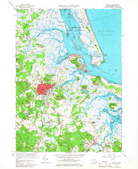
1966 Map of Ipswich
USGS Topo · Published 1967About this map
The complex coastal geography of the North Shore is defined by the labyrinthine channels of Plum Island Sound and the extensive tidal flats surrounding Little Neck and Castle Neck. Inland, the settlement of Ipswich serves as a central hub, with its historic street grid featuring Washington St and Central St clustered near the Ipswich River. The landscape reveals a diverse mix of mid-century land use, from the academic and religious presence of the Sisters of Notre Dame de Namur Novitiate and Sacred Heart Juniorate to the scientific operations at the Air Force Cambridge Research Laboratories. To the east, the preservation of the coast is evident in the Parker River National Wildlife Refuge and Plum Island State Park, while the southern reaches near South Essex show the agricultural and residential transition toward the neighboring town of Hamilton.
Find a feature on this map
141 named features on this map. Tap any name to fly to it.
Don’t see what you’re looking for? This feature index may not catch every label — zoom into the map to look around manually.
Map Details
Editions of this 1966 Ipswich Map
Other maps of this area

1886 · Gloucester
USGS Topo · 1:62,500

1888 · Newburyport
USGS Topo · 1:62,500

1888 · Gloucester
USGS Topo · 1:62,500

1888 · Salem
USGS Topo · 1:62,500

1890 · Newburyport
USGS Topo · 1:62,500

1893 · Salem
USGS Topo · 1:62,500

1893 · Gloucester
USGS Topo · 1:62,500

1894 · Newburyport
USGS Topo · 1:62,500

1917 · Salem
USGS Topo · 1:62,500

1918 · Gloucester
USGS Topo · 1:62,500