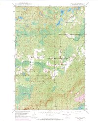
1949 Map of Isaac Lake
USGS Topo · Published 1971About this map
The Minnesota State Forest and portions of the Superior National Forest define this landscape in St. Louis County, recorded during a 1949 field check and updated with 1969 aerial revisions. The terrain is characterized by a dense network of water bodies, including Isaac Lake, Arthur Lake, and the smaller Kaunonen Lake. Human infrastructure is sparse, concentrated primarily around the Town Hall and a few small roads that cut through the townships of Waasa and Argo.
Find a feature on this map
24 named features on this map. Tap any name to fly to it.
Don’t see what you’re looking for? This feature index may not catch every label — zoom into the map to look around manually.
Map Details
Editions of this 1949 Isaac Lake Map
4 editions found
Other maps of this area

1933 · Ely
USGS Topo · 1:62,500

1939 · Ely
USGS Topo · 1:62,500

1949 · Aurora
USGS Topo · 1:24,000

1949 · Isaac Lake
USGS Topo · 1:24,000

1949 · Allen
USGS Topo · 1:24,000

1949 · Embarrass
USGS Topo · 1:24,000

1950 · Isaac Lake
USGS Topo · 1:24,000

1950 · Embarrass
USGS Topo · 1:24,000

1950 · Allen
USGS Topo · 1:24,000

1950 · Aurora
USGS Topo · 1:24,000