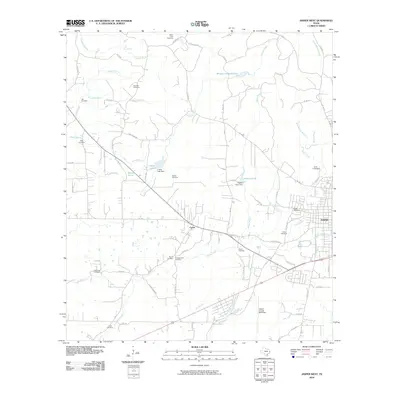
2010 Map of Jasper West
USGS Topo · Published 2010About this map
Jasper serves as the focal point of this East Texas survey, where the city's western edge meets a landscape defined by an intricate network of creeks and numerous rural burial grounds. The settlement of Curtis sits along the roadway north of Sandy Creek, marking a transition from the developing town outskirts to more secluded timber and pasture lands. This map is particularly dense with genealogical markers, documenting over a dozen named cemeteries including Watts-Fuller Cemetery, Gilgal Cemetery, and the poignantly named Little Hope Cemetery. Water management and recreation are evident through features like Morgan-Lindsey Lakes and Pattons Pond, while the Jasper County-Bell Field indicates the region's mid-century aviation infrastructure. The drainage patterns of Trotti Creek and Indian Creek illustrate the natural topography that has long shaped movement and land use in this part of the Piney Woods.
Find a feature on this map
82 named features on this map. Tap any name to fly to it.
Don’t see what you’re looking for? This feature index may not catch every label — zoom into the map to look around manually.
Map Details
Editions of this 2010 Jasper West Map
This is the sole edition of this map. No revisions or reprints were ever made.
Other maps of this area

1952 · Lake Charles
USGS Topo · 1:250,000

1953 · Alexandria
USGS Topo · 1:250,000

1953 · Palestine
USGS Topo · 1:250,000

1954 · Lake Charles
USGS Topo · 1:250,000

1954 · Beaumont
USGS Topo · 1:250,000

1955 · Alexandria
USGS Topo · 1:250,000

1955 · Roganville
USGS Topo · 1:62,500

1955 · Curtis
USGS Topo · 1:62,500

1957 · Beaumont
USGS Topo · 1:250,000

1957 · Palestine
USGS Topo · 1:250,000