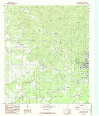
1984 Map of Jasper West
USGS Topo · Published 1985About this map
The western edge of Jasper anchor this East Texas landscape, which is defined by a dense network of timbered ridges and creek bottoms. Small settlements like Peachtree, Curtis, Yates, and Louis appear as clusters of homes and small farms connected by a web of rural roads. The area's aviation history is represented by the Jasper County-Bell Field south of the main town.
Find a feature on this map
27 named features on this map. Tap any name to fly to it.
Don’t see what you’re looking for? This feature index may not catch every label — zoom into the map to look around manually.
Map Details
Editions of this 1984 Jasper West Map
This is the sole edition of this map. No revisions or reprints were ever made.
Other maps of this area

1952 · Lake Charles
USGS Topo · 1:250,000

1953 · Alexandria
USGS Topo · 1:250,000

1953 · Palestine
USGS Topo · 1:250,000

1954 · Lake Charles
USGS Topo · 1:250,000

1954 · Beaumont
USGS Topo · 1:250,000

1955 · Alexandria
USGS Topo · 1:250,000
1955 · Roganville
USGS Topo · 1:62,500
1955 · Curtis
USGS Topo · 1:62,500

1957 · Beaumont
USGS Topo · 1:250,000

1957 · Palestine
USGS Topo · 1:250,000