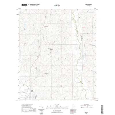
2018 Map of Jones
USGS Topo · Published 2018About this map
Valley Grande and the neighboring small communities of Jones and Vine Hill anchor this rural landscape along the boundary of Dallas and Autauga counties. The terrain is defined by the winding course of Mulberry Creek to the east and the watershed of Valley Creek to the west, where localized water features like Rex Waldrop Lake and Laurence Lake are found. This map provides critical detail for genealogists, as it preserves the locations of several family and community burial grounds, including Welch Cem, Barnes Cem, and Pea Ridge Cem. The transportation network is a web of county roads and local connectors such as Citizens Pkwy and Grist Rd, illustrating the modern layout of these established Alabama settlements. Tracing the path of the Valley Creek drainage toward Valley Creek Junction reveals the quiet, creek-bottom topography characteristic of this part of the state.
Find a feature on this map
62 named features on this map. Tap any name to fly to it.
Don’t see what you’re looking for? This feature index may not catch every label — zoom into the map to look around manually.
Map Details
Editions of this 2018 Jones Map
This is the sole edition of this map. No revisions or reprints were ever made.
Other maps of this area

1891 · Clanton
USGS Topo · 1:125,000

1953 · Montgomery
USGS Topo · 1:250,000

1956 · Montgomery
USGS Topo · 1:250,000

1957 · Montgomery
USGS Topo · 1:250,000

1957 · Benton
USGS Topo · 1:62,500

1958 · Selma
USGS Topo · 1:62,500

1958 · Selma
USGS Topo · 1:24,000

1959 · Plantersville
USGS Topo · 1:62,500

1959 · Summerfield
USGS Topo · 1:62,500

1975 · Plantersville SE
USGS Topo · 1:24,000