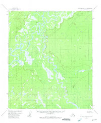
1952 Map of Kantishna River B-1
USGS Topo · Published 1975About this map
Toklat River and the Kantishna River dominate this interior landscape, winding through a complex network of wetlands and oxbow lakes. The 1952 topography, which received minor revisions in 1973, captures a region defined by its shifting waterways and seasonal drainage. Evidence of human presence is sparse in this subarctic terrain, centered primarily on the small settlement at Toklat and scattered Cabins located near the riverbanks. The mapping of Clear Creek further illustrates the intricate hydrologic pattern of the basin. This survey by the Bureau of Land Management and the U.S. Geological Survey offers a look at a remote wilderness before modern infrastructure, where travel was dictated by the rise and fall of the glacial rivers.
Find a feature on this map
5 named features on this map. Tap any name to fly to it.
Don’t see what you’re looking for? This feature index may not catch every label — zoom into the map to look around manually.
Map Details
Editions of this 1952 Kantishna River B-1 Map
3 editions found
Other maps of this area

1948 · Kantishna River
USGS Topo · 1:250,000

1950 · Fairbanks
USGS Topo · 1:250,000

1951 · Kantishna River
USGS Topo · 1:250,000

1951 · Fairbanks
USGS Topo · 1:250,000

1952 · Kantishna River C-1
USGS Topo · 1:63,360

1952 · Fairbanks A-6
USGS Topo · 1:63,360

1952 · Kantishna River A-1
USGS Topo · 1:63,360

1952 · Kantishna River
USGS Topo · 1:250,000

1952 · Kantishna River A-2
USGS Topo · 1:63,360

1952 · Kantishna River B-1
USGS Topo · 1:63,360