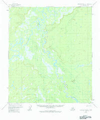
1952 Map of Kantishna River B-1
USGS Topo · Published 1984About this map
The Toklat River and Kantishna River dominate this interior Alaskan landscape, shown here as a complex network of meandering channels and oxbow lakes. In the early 1950s, this region remained largely untouched by modern infrastructure, defined instead by its natural drainage patterns and seasonal wetlands. The small settlement of Toklat and a cluster of nearby Cabins represent the limited human footprint in the area, likely serving as remote outposts for trapping or subsistence activities. The presence of Clear Creek and numerous unnamed tributaries winding through the lowland swamps highlights the shifting nature of the riverbeds during this era. This survey, based on 1952 aerial photography, provides a record of the unsurveyed and unmarked land lines as predetermined by the Bureau of Land Management before significant development or modern environmental changes altered the corridor.
Find a feature on this map
5 named features on this map. Tap any name to fly to it.
Don’t see what you’re looking for? This feature index may not catch every label — zoom into the map to look around manually.
Map Details
Editions of this 1952 Kantishna River B-1 Map
3 editions found
Other maps of this area

1948 · Kantishna River
USGS Topo · 1:250,000

1950 · Fairbanks
USGS Topo · 1:250,000

1951 · Kantishna River
USGS Topo · 1:250,000

1951 · Fairbanks
USGS Topo · 1:250,000

1952 · Kantishna River C-1
USGS Topo · 1:63,360

1952 · Fairbanks A-6
USGS Topo · 1:63,360

1952 · Kantishna River A-1
USGS Topo · 1:63,360

1952 · Kantishna River
USGS Topo · 1:250,000

1952 · Kantishna River A-2
USGS Topo · 1:63,360

1952 · Kantishna River B-1
USGS Topo · 1:63,360